
Regional Deformation Monitoring
Working Package 2 (WP2) of the DAMAST and DAMAST-Transfer projects, running from 2019 to 2024, focuses on monitoring regional and local deformation in the Enguri region, with particular attention to the Enguri Dam. By utilizing a combination of GNSS (Global Navigation Satellite Systems) and InSAR (Interferometric Synthetic Aperture Radar) technologies, both vertical and horizontal displacement patterns are closely monitored. The primary objective is to evaluate the dam’s response to varying load conditions, as well as to analyze fault shearing at the local Ingirishi Fault and regional strain in this tectonically active region.
GNSS Network
Since October 2020, the GNSS network has been partially operational, with the complete network comprising ten permanent stations: four positioned directly on the dam crest and six in the surrounding areas of the Enguri reservoir. These six regional stations are equipped with state-of-the-art GNSS technology, including multi-frequency receivers and choke-ring antennas. The four dam stations are powered by the local grid, while the regional stations are solar-powered. Each is anchored in concrete pillars with foundations extending up to 1.5 meters deep, ensuring protection against frost. The station locations have been strategically selected to support the project’s objectives. Each station records raw data from visible GPS and GLONASS satellites every 30 seconds, transmitting the data to the institute’s servers for further processing. Figure 1 illustrates the locations of the six regional GNSS stations.
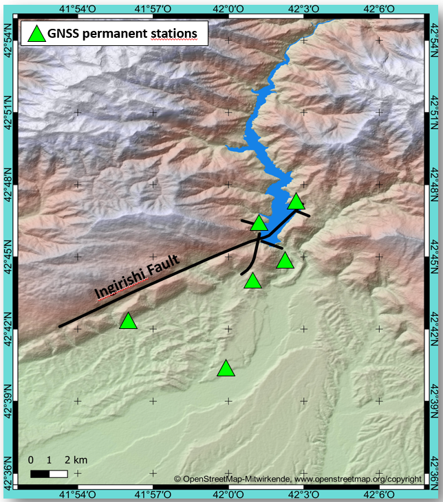
Additionally, ten GNSS campaign points have been placed along the eastern shore of the reservoir and in the southern foreland, intersecting the local Ingirishi Fault. These points are measured biannually, in April and September, to monitor regional shear movements and compressive tectonic activity, aligning with the reservoir’s water level extremes.
InSAR
InSAR data is collected across three SAR frequency bands: X-band (TerraSAR-X), C-band (Sentinel-1), and L-band (ALOS-2). X-band data, with its short wavelength, is particularly suited for high-resolution monitoring of the dam structure and exposed slopes, offering precise detail for detecting small-scale deformations. C-band data, with its moderate wavelength, provides valuable insights into regional deformation patterns, and its long time series and open availability through Sentinel-1 make it especially promising for long-term monitoring and trend analysis. L-band, with its longer wavelength, excels in penetrating vegetation and is advantageous for monitoring broader regional deformation, particularly in forested or rugged terrain where other bands face limitations.
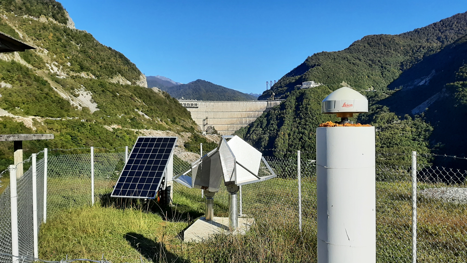
Six radar corner reflectors installed in the Enguri region, near the GNSS sensors, are designed to enhance the accuracy of Persistent Scatterer Interferometry (PSI). These reflectors, securely anchored on solid concrete foundations and precisely aligned with Sentinel-1 orbits, ensure consistent and reliable long-term measurements. Furthermore, the co-location of GNSS and InSAR data allows for their integration, offering a more comprehensive and precise analysis of deformation patterns across the region. Figure 2 shows a geodetic station near the Enguri Dam with two radar reflectors and a GNSS sensor.
GNSS measurements
Data from the six permanent regional stations exhibit low noise levels in their time series, demonstrating high precision and the ability to detect even subtle deformations. Notably, a distinct step, recorded on February 6, 2023, was observed across all six stations, corresponding to a seismic event in Turkey/Syria. The measured displacement of approximately 6 mm aligns with expectations for an earthquake occurring 300 km away. This event highlights the stations' sensitivity to small movements and underscores the quality and stability of their installation on solid foundations.
Seasonal variations are apparent in the GNSS stations near the reservoir, with the coordinate time series showing periodic changes that correspond to fluctuations in water levels. These variations suggest that water levels may influence the observed deformations; however, it remains challenging to differentiate this effect from seasonal atmospheric factors. Nevertheless, the direction of the movement is consistent with expectations from a simple water-loading model.
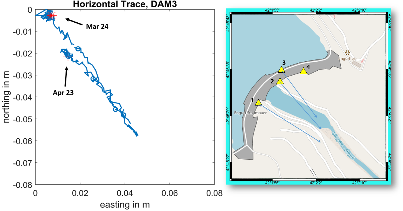
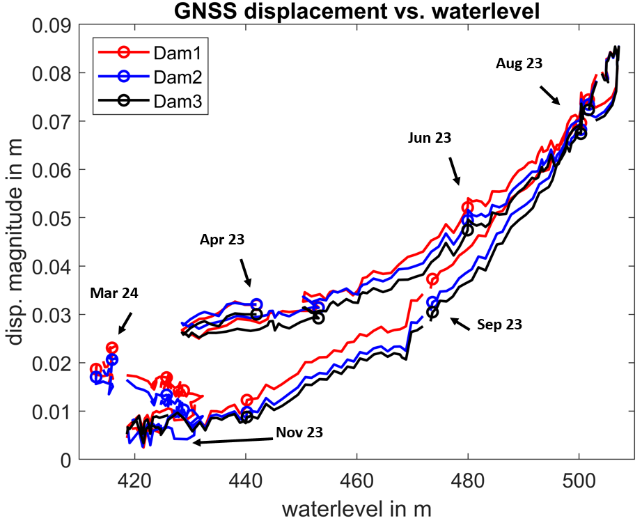
Since April 2023, the four GNSS stations on the dam's crest have recorded significant displacement amplitudes, reaching up to 8 cm, in direct correlation with water level fluctuations. Displacement directions vary based on station location along the dam's crest, with movements generally towards the dam’s centerline. The trajectory in the horizontal plane reveals a slight hysteresis effect, where displacement patterns differ between rising and falling water levels, as shown in Figure 3.
Further analysis highlights a close alignment between deformation patterns and water level changes. From November 2023 to March 2024, a consistent linear deformation trend was observed, suggesting that temperature variations, rather than water levels, were the primary driver during this period of stable reservoir levels as shown in Figure 4.
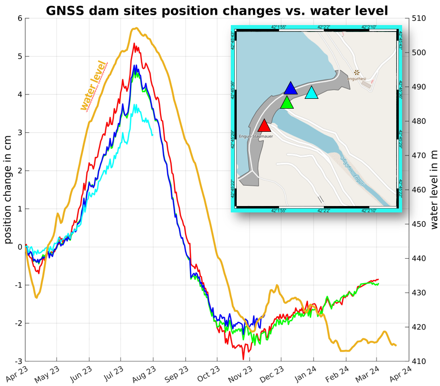
A comparison of water levels against displacement amplitudes shows a non-linear relationship, indicating that the dam’s bending stiffness decreases as water levels rise, likely due to the dam's thinner upper sections. Moreover, a pronounced hysteresis effect becomes apparent, where deformation amplitudes differ during the rising and falling phases of the water level cycle. This suggests a delayed structural response to changes in water load. The delay in the dam’s adjustment to these variations, particularly during periods of low water levels, is further attributed to a slow adaptation to ambient temperature changes. This delay can reach up to 2 to 3 cm, reflecting the complexity of the dam's response to both hydrological and environmental factors, as shown in Figure 5.
InSAR observations
The processing of radar data presents significant challenges in certain aspects. L-band data from ALOS-2, in particular, are heavily affected by ionospheric interference, making the ionosphere a limiting factor for the feasibility of interferometric analyses in the L-band. Similarly, the analysis of X-band data poses its own difficulties. The accuracy of both the coregistration process and the digital elevation model (DEM) at the dam site plays a critical role in determining the outcome. Ensuring precise DEM alignment is especially crucial for obtaining reliable deformation measurements along the dam structure.
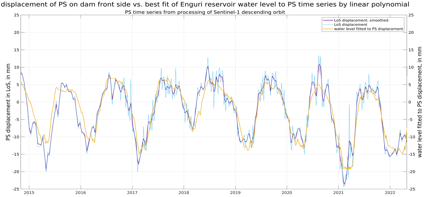
The freely available C-band data from Sentinel-1 have been processed interferometrically, utilizing both ascending and descending orbits. The time series spans from 2015 to the present, offering a valuable dataset for long-term deformation analysis. In non-vegetated areas, a significant number of Persistent Scatterer (PS) points were successfully detected, while, as expected, the identification of PS points in forested regions proved challenging due to reduced coherence. The linear velocities of the detected PS points indicate moderate movement, with no pronounced large-scale deformation patterns being observed.
In the descending orbit, which provides a favorable view of the dam’s front face, a noticeable number of coherent scatterers have been established. The Line of Sight (LOS) displacement observed in these scatterers is phase-correlated with fluctuations in the reservoir's water levels. Specifically, the LOS shortens by approximately 0.2 mm for every meter increase in water level, with displacement amplitudes reaching up to 30 mm. This suggests a clear relationship between the dam's structural response and the varying hydraulic load imposed by changing reservoir levels. As shown in Figure 6, the observed displacement amplitude is smaller compared to GNSS measurements, primarily because the PS are located on the dam wall rather than the crest, where GNSS sensors are positioned. Additionally, displacement is measured in LOS rather than 3D, as with GNSS.
Since the radar corner reflectors were established during the course of the project, they did not appear as Persistent Scatterers (PS) in the extended Sentinel-1 time series. Consequently, the time series was shortened to evaluate the quality of the installations. This processing initiative aimed to assess the reflectors' performance. The results indicate that PS points have emerged at the locations of the corner reflectors, revealing smooth and stable deformation time series. The corner reflectors have demonstrated the potential to detect deformations with millimeter-level precision.
Contributions
The DAMAST and DAMAST-Transfer projects have advanced the monitoring of deformation in the Enguri region. The integration of GNSS and InSAR technologies, along with radar corner reflectors, has provided a detailed understanding of the dam’s structural behavior and regional deformation patterns. The GNSS network has demonstrated high precision in detecting subtle displacements and responding to load variations and seasonal changes. InSAR data has offered insights into broader deformation patterns. The radar corner reflectors have enhanced the accuracy of Persistent Scatterer Interferometry (PSI). The geodetic measurement network established in the Enguri region represents a significant contribution to geodetic monitoring. This infrastructure not only supports current assessments but also provides a solid foundation for future research and monitoring efforts.